
Wikiloc - Trails of the World vVARY
Wikiloc Outdoor


About this app
Developer Description
Discover millions of trails for hiking, biking, trekking, GPS navigation routes
Wikiloc is the go-to outdoor navigation application for hiking, cycling, and over 80 other outdoor activities with millions of members worldwide. Find your favorite trails among authentic routes created by the community, record your own and share it, easily transfer it to your GPS device, and more features to enjoy nature whenever you want.
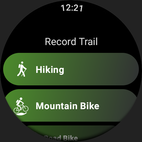
Engage in outdoor sports:
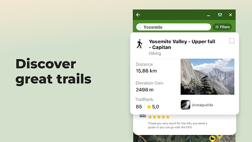
Choose from 50 million hiking, trekking, biking (MTB, road cycling, gravel), trail running, mountaineering, climbing, kayaking, skiing, and up to 80 different types of activities.
Authentic nature trails:
Wikiloc routes have been recorded with GPS and created by community members — nature and outdoor sports enthusiasts like you.
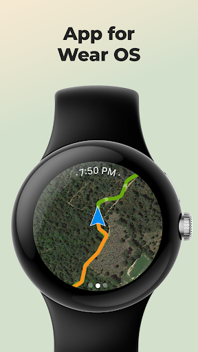
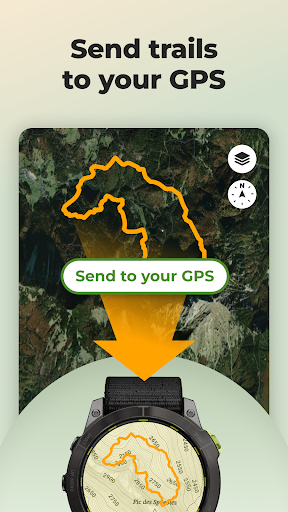
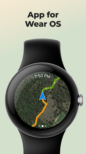
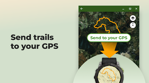
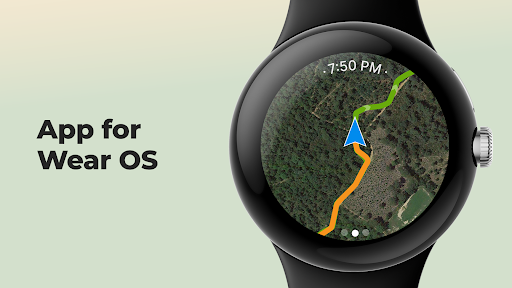
Send routes to your GPS or smartwatch:
Enjoy the experience from your wrist or mobile. Download Wikiloc routes directly to your Wear OS, Garmin, Suunto or COROSsports watch or bike computer.
Available for devices like Garmin Forerunner, Fenix, Epix, Edge, and many more. You can also record and follow routes on a map from your Samsung Galaxy Watch, Pixel Watch, Fossil, Oneplus, Xiaomi, or TicWatch (minimum Wear OS 3 version).
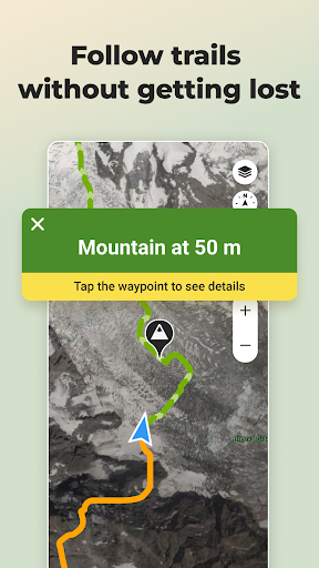
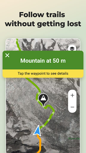
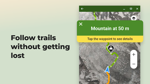
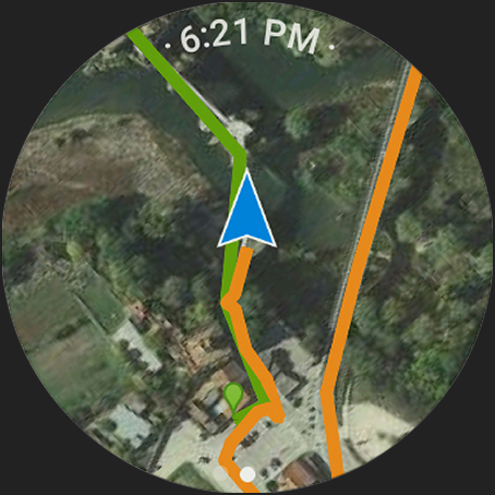
Outdoor Navigation: stay on track:
✅ Turn your mobile phone or smartwatch into a GPS navigator. Your smartphone will guide you with a direction indicator and sound alerts to notify you if you stray off the path during navigation.
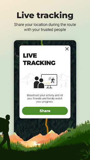
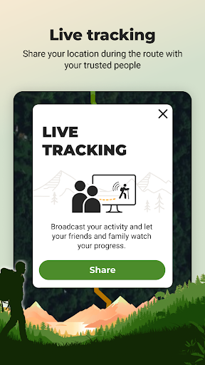
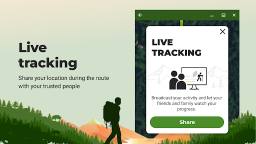
✅ Live GPS route tracking. Share your real-time location with family and friends while you're on the route, so they know where you are at all times.
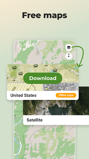
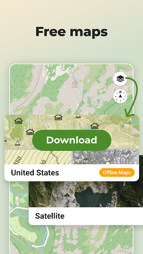
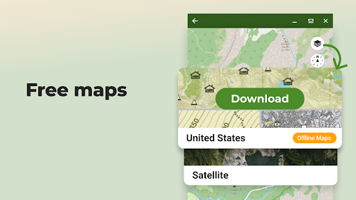
✅ Offline GPS navigation through free topographic maps worldwide for use without coverage or data. Ideal for when you're in the mountains or traveling without an internet connection or with a low battery.
Official routes for all audiences 🏔️🥾♿
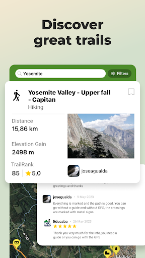
Explore free GPS walking routes through national parks (including routes adapted for reduced mobility and visual impairment), trekking on mountain trails, routes by waterfalls, and more in the largest hiking and cycling community (or bike trails) around you.
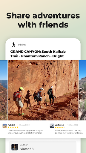
Follow local iconic routes on foot or climb the most famous mountain passes. Become part of the community where millions of nature, travel, and sports lovers share their adventures, from the most popular hike to the most remote trekking expedition on the planet.
Find the perfect route for your next adventure, through Premium features such as:
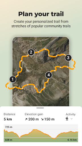
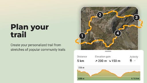
✅ Route Planner: Plan your next adventure easily. Simply choose the places you want to pass through and Wikiloc will create a route prioritizing the most popular stretches of trails from other community members.
✅ 3D Maps: Explore trails with more depth and detail. Without leaving home, discover the terrain relief, evaluate elevation changes, and take a look at the panoramic views that await you along the way.
✅ Advanced search filters: by elevation gain, distance, difficulty, and season (winter/summer).
✅ Search by passing area: find routes that pass through the places of interest you choose and plan your ideal itinerary.
✅ Weather forecast for a perfect outing.
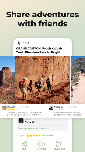
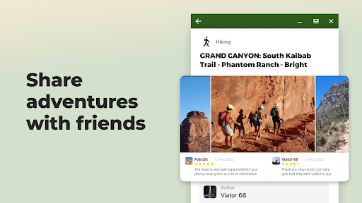
Create and share your adventures
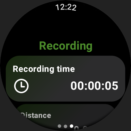
Record your own outdoor routes on a map, add waypoints, take photos of the landscapes along the itinerary, and upload them to your Wikiloc account from your mobile phone. Share your adventures with friends, family, and community followers.
Commitment to the planet
With Wikiloc Premium, you not only help us continue to improve Wikiloc, but you also contribute to protecting the Earth, as 1% of your purchase goes directly to 1% for the Planet, a global network of companies, nonprofit organizations, and individuals working together for a healthy planet.f
What's New
Point your camera at nearby peaks and watch names and elevations appear in real-time AR. Swipe to align the 3D terrain, discover iconic and hidden summits — internet required.
In-app purchases
$0.99 - $19.99 per item
Version Information
- Version
- -
- Downloads
- 10M+
- Updated on
- Dec 18, 2025
- Released
- Feb 17, 2012
- Requires
- Android Varies with device
Statistics
Google Play Rating History
Rating Distribution
Downloads Over Time
Wikiloc - Trails of the World has been downloaded times. Over the past 30 days, it averaged downloads per day.
Shaded area shows 30-day prediction based on historical trends
Historical data collection started recently. More data points will be available over time.
Wikiloc - Trails of the World - Google Play Rankings
Top Rankings
| Rank | Country | Category | List | Change |
|---|---|---|---|---|
| — |
Ranking History in
No ranking data available yet. Rankings are updated daily.
#51 in Top Grossing Maps And Navigation in United States
 Speedometer: GPS Speedometer
Wikiloc - Trails of the World
Speedometer: GPS Speedometer
Wikiloc - Trails of the World
 Flight Tracker - Flight Radar
#1 in Top Grossing Maps And Navigation in Italy


#1 in Top Grossing Maps And Navigation in Spain

#2 in Top Grossing Maps And Navigation in Mexico

Wikiloc - Trails of the World users say on Google Play
 Ivan Grigorev
Great app for hiking. Trails uploaded (and tested) by other hikers. 3d viewer of the trail. Other hikers' estimate of trail difficulty tends to be optimistic. Used it in Albanian alps – many good trails!
 Alistair Street
Fantastic app, you can select lots of different activities and choose your area with downloadable offline maps in case you lose signal. You can also upload your hikes or drives into the app for other users. One problem however on the 4x4 off road filter is that many users have uploaded drives on normal roads and there needs to be some curating of the content because if you are searching for off road tracks, you don't want to see someone's drive who stayed on tarmac.
 Ben Ferry
great app, but I don't understand why the 'plan trail' option doesn't support boat trips. I use the app for kayaking, for which it is excellent, but not being able to plan a kayak trip like you can for hiking is quite frustrating.
 Andrew Weir
First half of the walk was wonderful but in the second half the "trail" disappeared and was blocked by three barbed wire fences which we had to climb with much difficulty. The last part of the trail guide is completely useless. Maybe the person who did it used a drone instead of walking it. Unless you are happy to stop the walk halfway and go back, or have strong wire cutters, don't go on this walk.
 Farhad FatahiBafghi
An application that is very slow in practice, and is really useless in sensitive situations. That is, if you went on a route where you wanted to use the experiences recorded in this app, you can't! Because you have to pay in advance! In fact, it exploits human freedom and health in a sensitive situation! Even when you go on a route yourself and save it, after a few hours you see that it wasn't saved because the application slows down at the end of the route!
ApkTrusted Ratings & Reviews
Similar Apps

AllTrails: Hike, Bike & Run
Free

OsmAnd — Maps & GPS Offline
Free

Cyclers: Bike Navigation & Map
Free

Avenza Maps: Offline Mapping
Free

swisstopo
Free
Offline Map Navigation
Free

Outdooractive. Hike and Ride
Free

Mapy.com: Offline hiking maps
Free

Geocaching®
Free

Gaia GPS: Offline Trail Maps
Free

MAPS.ME: Offline maps GPS Nav
Free

komoot - hike, bike & run
Free
Geo Tracker - GPS tracker
Free

Locus Map Outdoor Navigation
Free

Strava: Run, Bike, Hike
Free
Sygic GPS Navigation & Maps
Free
Scan this QR code to download

Forwarding you to the page at Google Play market in seconds...
Open Google Play market now