
Cartes IGN v3.4.1
IGN-France


About this app
Developer Description
Discover France differently and observe the evolution of the territory
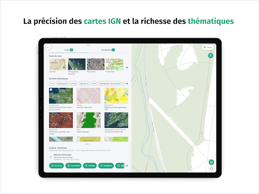
Good plan ! Click on the interactive map to obtain additional information on French territory such as the characteristics of a building or the type of cultivation of a field.
Fly over France and observe the evolution of French landscapes in times of climate change by comparing, like a geographer, IGN maps or aerial photographs from different eras. Seen from the sky, the mark of man on the territory is surprising!
Discover points of interest around you thanks to IGN Maps, a mapping application for everyone, easy to use, which also offers all the practical tools to get around without being tracked: calculate a route, trace a route, create and save a landmark, display your position and share it with loved ones…
Set off to discover the French territory with IGN Maps!
What's New
- Nouveau menu dans la section Explorer qui présente les cartes de l'atelier de cartographie thématique de l'IGN
- Possibilité d'ajouter à Enregistrés des itinéraires calculés via S'y rendre
- Affichage des informations en temps réel de l'enregistrement de trace GPS
Corrections :
- Améliorations du support des fichiers GPX importés
- Correction de problèmes d'affichage des cartes hors ligne
Version Information
- Version
- 3.4.1
- Downloads
- 1M+
- Updated on
- Dec 9, 2025
- Released
- Jun 11, 2015
- Requires
- Android 6.0
Statistics
Google Play Rating History
Rating Distribution
Downloads Over Time
Cartes IGN has been downloaded times. Over the past 30 days, it averaged downloads per day.
Shaded area shows 30-day prediction based on historical trends
Historical data collection started recently. More data points will be available over time.
Cartes IGN - Google Play Rankings
Top Rankings
| Rank | Country | Category | List | Change |
|---|---|---|---|---|
| — |
Ranking History in
No ranking data available yet. Rankings are updated daily.
#41 in Top Free Travel And Local in France


Cartes IGN users say on Google Play
 A Google user
Great for showing location when walkinh. Amazingly detailed.
A Google user
Très bonne appli mais pourquoi pas les carte oaci comme sur le site web? Et pourquoi pas de sauvegarde des map en mode hors ligne...? Même s'il faut payer ce serais bien...
A Google user
Good for what it is, which is not much. Given how great the website is you'd hope for more. The trouble is, if they did it properly they'd put a whole profession out of business. Still the cadastrale are useful with the too faint layer of sattelite. A better user than me could probably find a way to make it work with Google. For sattelite tracking on the ground.
A Google user
This is a review of the app only, not the data or excellent web interface through which it is accessible using a desktop browser. Géoportail is a French web mapping service which includes numerous base maps and even more useful data overlays. There are historical maps back to the 1600s, aviation maps, drone regulation maps, various satellite and aerial photo backgrounds, etc. This app offers only 6 base maps (not the most useful ones). No overlays and no legends are included. The drone regulation map would be extremely useful to have on mobile, but it isn't accessible using this app. The app functionality is so limited, I see little reason to use it at all. Unfortunately, the Géoportail website only works on desktop, thus there is no way at all to access its excellent data on mobile. There are also minor bugs such as weird scrolling and the occasional notification by my phone that this app is using too much battery in the background.
A Google user
Lorque que partez en rando en montagne et vous arrivez hors portée internet, la carte disparait, lorsque vous en avez le plus besoin (y compris le bout de carte que vous aviez dejà à l'écran). Le pire, est que lorsque internet revient, la carte ne revient pas forcément. Essayez vous-mêmes à la maison: affichez une carte, mettez votre portable en mode avion, remettez internet, et le plus souvent, la carte ne revient pas. Cette application est un désastre. Suggestion aux développeurs: il faudrait pouvoir montrer a l'application avec la caméra qu'on possède la carte papier, par un code barres, et ensuite pouvoir garder cette carte offline.
ApkTrusted Ratings & Reviews
More from IGN-France
See more apps


Similar Apps

Südtirol Fishing
Free
National Park Service
Free

Trippy Tour Guide
Free

Outdooractive. Hike and Ride
Free

eBike Flow
Free

SmartGuide: Digital Tour Guide
Free

Polarsteps
Free

Gaia GPS: Offline Trail Maps
Free

Footpath Route Planner
Free

bergfex: Hiking & Tracking
Free

Bike Route Planner
Paid
park4night - Motorhome camper
Free

Bonjour RATP
Free

swisstopo
Free
Scan this QR code to download

Forwarding you to the page at Google Play market in seconds...
Open Google Play market now