Waterkaarten: Boat Navigation v11.16.1
Waterkaarten


About this app
Developer Description
Sail easily and safely with the Waterkaarten app
With the Waterkaarten app (formerly ANWB Waterkaarten) you have everything you need at hand:
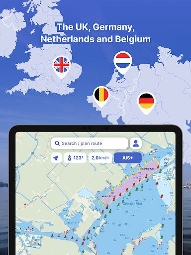
• 8 countries, 1 price: Complete nautical maps of the United Kingdom and Ireland, Netherlands, Germany, France, Belgium, Denmark and Switzerland
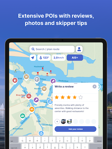
• Almanack info: Access all information you need on the water with just a few taps in the app
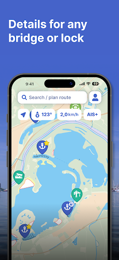
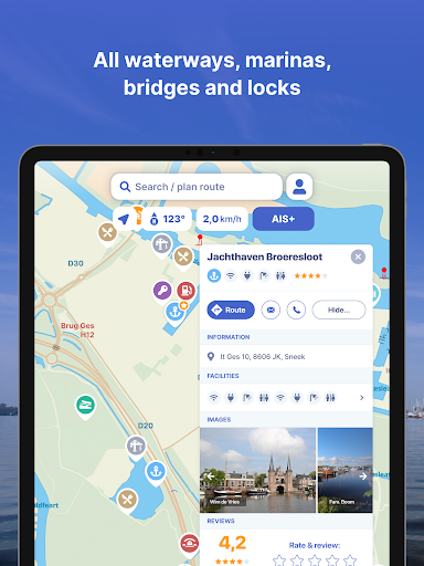
• Current information about marinas, bridges and locks including opening times
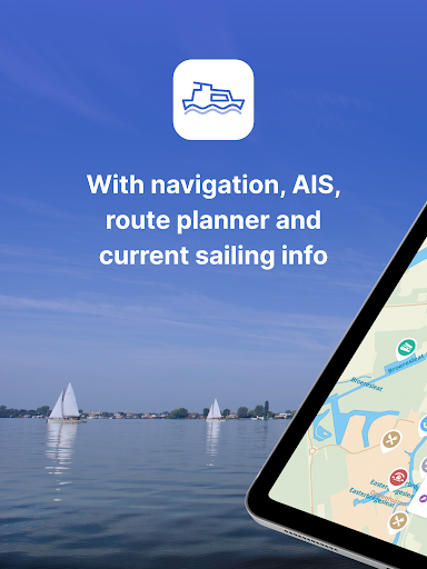
• Plan optimal routes between your starting point and destination, including the objects you encounter
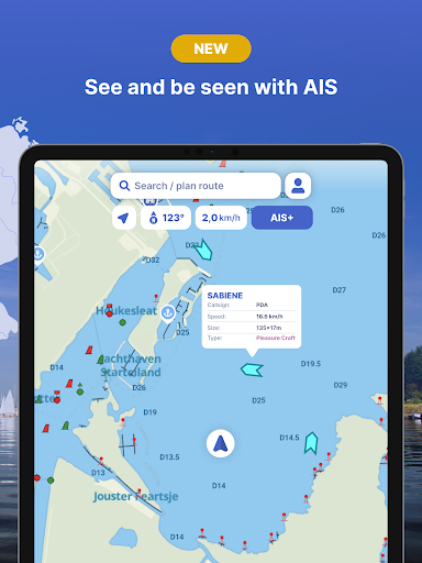
• AIS+: See all the boats near you on the water and at rest including their names and speed with just a tap
• AIS pairing: Connect your AIS device to the app and see at a glance where surrounding ships are located
• Coming soon: Expanded hydrography coverage - visual depth guides along Western European coastlines
Comprehensive and user friendly:
• Locations of more than 8,000 marinas and all details of their existing facilities
• More than 275,000 nautical objects (bridges, locks, markings, mooring places and more)
• Stay up-to-date with the current navigation reports and obstructions from government agencies such as Rijkswaterstaat
• Regular updates and free access to all new features
• Show or hide 60 different layers of information on the nautical maps to see exactly what you need
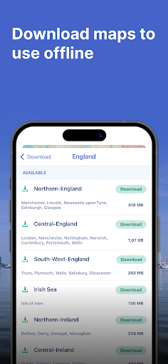
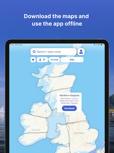
• Radio silence on the water? No problem! Download the corresponding charts for offline use
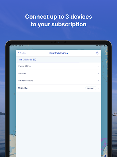
• Each user account can be used on up to 3 devices at no extra cost
• Free Windows version included
• Reliable service: We are at your service 7 days a week - simply email us at support@waterkaarten.app
How it works:
The Waterkaarten app is free during the 7-day trial. After that you can choose from the following subscriptions:
• Month (£ 11.99)
• Season (3 months for £ 32.99)
• Year (£ 45.99)
The subscription ends after credit expires. Subscriptions are not automatically renewed.
If you purchase a subscription during the free 7-day trial period, we will add your new credit to your remaining balance.
Payment methods for subscription:
• The subscription will be charged to your Google account
• At Google you can use different payment methods, such as PayPal or credit card
Even more boating pleasure with a Waterkaarten account: you can create an account in the app to activate your subscription on a total of 3 devices.
Note:
• The file size of the offline map material is very large and you are advised to download it on a stable Wi-Fi connection
• Prolonged use of GPS in the background can considerably shorten the battery life of your device
Do you have questions about the app? Please contact our helpdesk (support@waterkaarten.app) or read more on our website: www.waterkaarten.app/en.
Please note that this app is only intended as an aid when navigating on the water. Stay alert to your surroundings while boating.
What's New
- Replaced all map icons with a sharper, clearer design
- Improved the display of buoys and other seamarks
- Made it possible to use emojis in saved names
- We also fixed a bug where some pins would not load after an update.
In-app purchases
$13.99 - $54.99 per item
Version Information
- Version
- 11.16.1
- Downloads
- 500K+
- Updated on
- Oct 8, 2025
- Released
- Apr 11, 2013
- Requires
- Android 11
Statistics
Google Play Rating History
Rating Distribution
Downloads Over Time
Waterkaarten: Boat Navigation has been downloaded times. Over the past 30 days, it averaged downloads per day.
Shaded area shows 30-day prediction based on historical trends
Historical data collection started recently. More data points will be available over time.
Waterkaarten: Boat Navigation - Google Play Rankings
Top Rankings
| Rank | Country | Category | List | Change |
|---|---|---|---|---|
| — |
Ranking History in
No ranking data available yet. Rankings are updated daily.
#13 in Top Grossing Maps And Navigation in Netherlands
 MarineTraffic - Ship Tracking
Waterkaarten: Boat Navigation
MarineTraffic - Ship Tracking
Waterkaarten: Boat Navigation
 Mapy.com: Offline hiking maps
#42 in Top Grossing Maps And Navigation in Germany
 Zeo Fast Multi Stop Route Plan
Waterkaarten: Boat Navigation
Zeo Fast Multi Stop Route Plan
Waterkaarten: Boat Navigation
 Odysseus GPS Truck Navigation
#54 in Top Grossing Maps And Navigation in Poland
 Cyclers: Bike Navigation & Map
Waterkaarten: Boat Navigation
Zeo Fast Multi Stop Route Plan
Cyclers: Bike Navigation & Map
Waterkaarten: Boat Navigation
Zeo Fast Multi Stop Route Plan
Waterkaarten: Boat Navigation users say on Google Play
 A Google user
This is a great app (probably the best one) for navigation in The Nederlands. It provides much more valuable information than the paper version of the ANWB waterkaart. For maximum benefit I recommend the use of a tablet, rather than a smartphone, because the larger screen area provides for the better overview. The most valuable feature is the indication of one's own position within the map, which is made possible by means of the location services of the tablet or smartphone. Because I travel frequently to the Nederlands for boating vacation, I decided for a yearly subscription.
 Robin Thomas
Been using this app for three years and it just keeps improving. The team behind the app are very responsive to feedback and always keep users informed. The automatic routing upgrade still in Beta shows promise but needs more work.
 Nick Reynolds
The app is generally good, the auto routing feature worked well for me. I wouldn't want to navigate the Netherlands without it. There are some factual errors. One bridge height was incorrect. One new bridge was missing. One bridge was noted as closed, but was open and there was no contact information for the bridge, and no way to comment on the bridge information. Auto routing didn't recognize the closure. Routing underestimated transit times for my slow boat, we should be able to set speed
 Steijn Roosendaal
whenever i try to turn the map around or zoom in/out the map starts flipping out, rotating like crazy. The location marker doesn't have the appropriate heading (it will just face north all the time) but the bridge information is correct. (Height, width, opening times)
 Bla Bla
Non functional routing basicly the map and info of almanac part 2. No live warnings of issues like blocked waterways etc. Additional comment 2 years later: the app requires access to the Facebook track& trace systems only visible after installing and inspecting with classyshark. Unbelievable anwb supports the Facebook sellout of personal data. Pity I can't assign zero stars.
ApkTrusted Ratings & Reviews
Similar Apps

Gaggle Paragliding, Ultralight
Free

Orca: Boat GPS, Charts, Routes
Free

swisstopo
Free

SIGNALERT
Free
Holland America Line Navigator
Free

Wavve Boating: Marine Boat GPS
Free

Magic Earth Navigation & Maps
Free
ShipAtlas - Ship Tracker
Free
Navionics® Boating
Free

SeaPeople Boat Travel Map
Free
VesselFinder
Free

HiiKER: The Offline Hiking app
Free
MarineTraffic - Ship Tracking
Free

GPS Essentials
Free
Windfinder: Wind & Weather map
Free

FarOut
Free
Scan this QR code to download

Forwarding you to the page at Google Play market in seconds...
Open Google Play market now