
onX Backcountry Trail Maps GPS v25.52.0
onXmaps


About this app
Developer Description
Discover hiking, biking & skiing adventures with GPS, 3D maps & guidebooks.
Plan your hiking, skiing, mountain biking, and climbing activities with trustworthy data. HD topographic maps, GPS tracking, and weather forecasts help you navigate confidently in unknown terrain. Toggle map layers to show nearby hazards such as wildfires or avalanches. Measure distance and elevation, and visualize your trip in 3D, even without cell service.
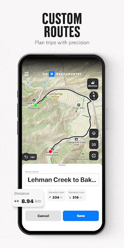
Map out custom routes seamlessly with our snap-to-trail feature and prepare in granular detail by setting Waypoints and reviewing Slope data. View localized weather and hour-by-hour wind forecasts. Discover adventures nearby with 650,000+ miles of trails, 300,000+ rock climbs, and 4,000+ ski routes.
Download 3D maps for offline use and leave a breadcrumb trail with Tracker to measure key trip stats. See in-depth terrain features with high definition topo maps and switch between Hike, MTB, Climb, or Ski Tour for an app that covers all your adventure needs.
Navigate confidently with powerful map tools and go farther with onX Backcountry today.
onX Backcountry Features:
▶ Ultimate GPS Map App for Outdoor Pursuits
• View trail maps in 3D, HD topo, satellite imagery or hybrid to visualize terrain
• Hiking, skiing, biking, and climbing become easier with custom map routes
• GPS tracking to know where you came from and share your trip
• Set Waypoints and access data on Slope Angle, Slope Aspect, and Trail Slope
▶ Map Modes for Every Adventure
• Hiking – Trail lengths, difficulty levels, elevation, and real-time GPS
• Backcountry skiing & snowboarding – Slope angles, SNOTEL data, and ATES layers
• Mountain biking – Biking paths, difficulty ratings, trail conditions, and elevation
• Rock climbing – Climbing routes, climb types, GPS tracking, and user reviews
▶ Navigate Offline without Cell Coverage
• Download 3D maps with interactive trail data. Turn your phone into a handheld GPS
• Track your location and follow the blue dot to get back to your starting point
• Measure hiking, biking, climbing or skiing stats to see where you’ve been
• View distance or elevation gain in seconds as you navigate in the field
▶ Scout Ahead & Stay Safe on your Trip
• Use the compass to find your location and orient yourself
• Access localized weather conditions, 7-day weather forecasts, and hourly wind data
• Hike confidently with Trail Reports. Submit current conditions and trail closures
• Plan ahead with ATES, wildfire, air quality, and smoke density layers
Your Four-Season Outdoor App
onX Backcountry brings everything you need for your outdoor adventures into one place. Download and start your next journey today!
▶ Free Trial
Start a Premium or Elite trial for free when you install the app. Maximize your backcountry experience and access all of our best features for seven days.
▶ Premium & Elite Features
• 650,000+ miles of running, hiking, backpacking, skiing, and mountain bike trails
• 4,000+ backcountry skiing lines with guidebook descriptions
• 300,000+ rock climbing routes with approach trails
• Offline 3D maps help you navigate without cell service
• 24K topographic maps and 3D maps for the entire U.S
• 985 million acres of Public Land across the U.S.
• 550,000 Recreation Icons: Trailheads, backcountry cabins, campgrounds, and more
• Map data sourced from USFS, BLM, and NPS
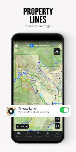
• Private Land Layer (ELITE ONLY): Property maps, land boundaries, land ownership, and acreage
• Recent Imagery (ELITE ONLY): Detailed satellite imagery from the past two weeks
▶ Terms of Use: https://www.onxmaps.com/tou
▶ Privacy Policy: https://www.onxmaps.com/privacy-policy
▶ Feedback: If you have any trouble or have an idea of what you’d like to see next, contact us at support@onxmaps.com.
In-app purchases
$14.99 - $99.99 per item
Version Information
- Version
- 25.52.0
- Downloads
- 500K+
- Updated on
- Jan 23, 2026
- Released
- Nov 27, 2020
- Requires
- Android 8.0
Statistics
Google Play Rating History
Rating Distribution
Downloads Over Time
onX Backcountry Trail Maps GPS has been downloaded times. Over the past 30 days, it averaged downloads per day.
Shaded area shows 30-day prediction based on historical trends
Historical data collection started recently. More data points will be available over time.
onX Backcountry Trail Maps GPS - Google Play Rankings
Top Rankings
| Rank | Country | Category | List | Change |
|---|---|---|---|---|
| — |
Ranking History in
No ranking data available yet. Rankings are updated daily.
#34 in Top Grossing Sports in United States


#54 in Top Free Sports in United States
 LiveScore: Live Sports Scores
onX Backcountry Trail Maps GPS
LiveScore: Live Sports Scores
onX Backcountry Trail Maps GPS
 TeamSnap: manage youth sports
#41 in Top Grossing Sports in Canada

onX Backcountry Trail Maps GPS users say on Google Play
 Brian Allen
I really struggled with this app at 1st & initially gave it a 1 star review. Now (after giving it a fair chance) I've completely changed my mind. I'm still learning the nuances of the app but it really is a phenomenal trail tool.
 R METZGER
I roam the mountains and valleys of Montana. onX is my partner!
 Steve Whitford
I primarily used it for trip planning, and for that it's fantastic. It has a great interface to plan a route, and the route snaps to the trail very well. it's annoying the app defaults to find nearby trails, but it's easy enough to go to tools. My problem is with the maps that it uses. Many campsites aren't listed, and one that is indicated on the map was removed 20 years ago (some trails too)! I mostly hike in New Hampshire, so other regions might be better. I'll stick to Caltopo/FarOut
 Chloe Lyles
Unfortunately not as reliable as OnX hunt. Even when maps are downloaded at high resolution, the offline map is extremely slow to load and grainy. The app has also reverted to basic subscription status when I'm offline, leaving me without access to the "elite" tools I paid for. Extremely disappointing, and possiby dangerous to rely on when recreating in backcountry environments.
 Joe Christiansen
If I could leave no stars I would. the map tools aren't that great limited map layer options too especially compared to CalTopo and even their free version is way better than this elite subscription which at $16 a month is twice what a caltopo subscription is. I cancelled my monthly elite subscription and without even asking me they automatically charged me for an annual premium. update: customer service was very helpful and got this issue sorted out! I will still be going back to CalTopo though
ApkTrusted Ratings & Reviews
More from onXmaps
See more apps


Similar Apps

HuntStand: GPS Maps & Tools
Free

BaseMap: Hunting Maps and GPS
Free

FarOut
Free

Trails Offroad: Offline Maps
Free
Recreation.gov
Free

Shaka Guide | GPS Audio Tours
Free

BassForecast: Fishing Forecast
Free

Deep Dive - Bass Fishing App
Free

Hipcamp: Camping, RVs & Cabins
Free

Regrid Property App
Free

Geocaching®
Free

HiiKER: The Offline Hiking app
Free

Watch Duty (Wildfire)
Free

Slopes: Ski & Snowboard
Free

Trucker Path: Truck GPS & Fuel
Free

Moultrie
Free
Scan this QR code to download

Forwarding you to the page at Google Play market in seconds...
Open Google Play market now