
Handy GPS (subscription) v44.8
BinaryEarth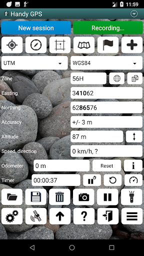


About this app
Handy GPS is a specialized navigation app designed for hikers and bushwalkers, offering a unique solution for those who need a reliable GPS companion in the great outdoors without requiring account creation. This app benefits outdoor enthusiasts the most, particularly those who frequently venture into areas with limited internet connectivity. Compared to other apps in the Maps And Navigation category, Handy GPS stands out with its focus on offline capability and simplicity, although it may fall short in terms of comprehensive map coverage and features compared to more general-purpose navigation apps. Its high user rating and moderate download numbers suggest a well-received app that effectively serves its niche audience.
Pros
- With a user rating of 4.2 out of 5, Handy GPS demonstrates a high level of user satisfaction, indicating that it meets the needs of its target audience effectively.
- The app's moderate download numbers of over 100,000 downloads provide social proof of its utility and popularity among outdoor enthusiasts.
- The absence of ads and a reasonable in-app purchase model contribute to a user-friendly experience, allowing users to enhance their experience without being bombarded with advertisements.
- The developer's reputation, as evidenced by their official website and contact information, suggests a commitment to supporting and updating the app, which is crucial for an app that relies on accuracy and reliability.
- The app's requirement for no permissions is a significant advantage, ensuring that users' privacy is respected and minimizing potential security risks.
Cons
- One concern is the potential limitation in map coverage and detail compared to more comprehensive navigation apps, which could be a drawback for users who need detailed maps for a wide range of locations.
- The in-app purchase model, while reasonable, might deter some users who prefer a one-time payment or are wary of subscription services, potentially limiting the app's appeal to a broader audience.
- The lack of information about the app's data collection practices, despite requiring no permissions, might raise questions about how the developer collects and uses data, if any, for app improvement or other purposes.
- Users with devices running Android versions lower than 5.0 are excluded from using this app, which could be a significant drawback for those with older devices.
Best for: The ideal user for Handy GPS is an outdoor enthusiast, likely an adult with a moderate to high level of technical skill, who regularly engages in hiking, bushwalking, or similar activities in areas with limited internet connectivity, and is looking for a reliable, easy-to-use GPS companion that does not require account creation or excessive permissions.
Developer Description
A hiking and bushwalking GPS for the real world. No account creation required.
This app requires payment of an annual subscription to be fully functional. If this is not paid it will still run, but with limited functionality.
This app is a powerful navigation tool designed for outdoors sports like hiking, bushwalking, tramping, mountain biking, kayaking, boating, horse trail riding, geocaching. Its also useful for surveying, mining, archaeology, and forestry applications. Its simple to use and works even in the remotest back country since it doesn't require network connectivity. It allows you to work in UTM or lat/lon coordinates so you can even use it with your paper maps.
NOTE: Allow the app to always use GPS, and turn off battery optimisation for the app to reliably record tracklogs when the phone screen is off.
BASE FEATURES:
* Shows your current coordinates, altitude, speed, direction of travel, and distance travelled in metric, imperial/US, or nautical units.
* Can store your current location as a waypoint, and record a track log to show where you've been on a map.
* Data can be imported from and exported to KML and GPX files.
* Allows manual entry of waypoints in UTM, MGRS and lat/lon coords.
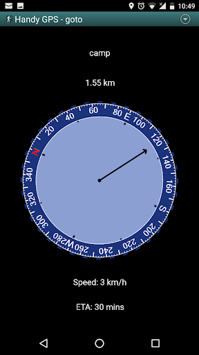
* Can guide you to a waypoint using the "Goto" screen, and optionally sound an alert when when you're getting close.
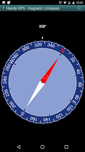
* Has a compass page which works on devices with magnetic field sensors.
* Automatically computes the local geoid offset to improve altitude accuracy
* Supports the world-wide WGS84 datum along with the common Australian datums and map grids (AGD66, AGD84, AMG, GDA94, and MGA). You can also use WGS84 for NAD83 maps in the US.
* Shows GPS satellite locations and signal strengths graphically.
* Can display simple or MGRS grid references.
* Can compute waypoint-to-waypoint distance and direction.
* Includes an optional timer line to record walk duration and compute your average speed.
* Thoroughly tested by the developer on many off-track walks
EXTRA FEATURES IN THIS VERSION:
* No ads
* Unlimited number of waypoints and track log points.
* Email or SMS your location to a friend as a clickable map link.
* Email your waypoints and tracklogs as KML or GPX file.
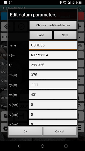
* Supports common datums such as NAD83 (US), OSGB36 (UK), NZTM2000 (NZ), SAD69 (South America) and ED50 (Europe), and you can configure your own custom datums, including local grid systems.
* UK grid refs with two letter prefixes can be shown if OSGB datum selected.
* Elevation profile.
* GPS averaging mode.
* Take photos and record voice memos, geo-located with KML files for easy viewing on a PC.
* Geo-tag photos, and/or have the coordinates and bearing "burnt" into the image.
* Sun rise and set times.
* Export data to CSV file.
* Create waypoint by triangulation, or projecting using an entered distance and bearing.
* Compute length, area, and elevation change for tracklog.
* Offline map support by downloading tiles from map tile servers, importing pre-prepared base maps from zip files, or registering your own map images.
* Compute calories.
* Optional background image.
* Optional location sharing on web.
* Spoken distance and direction guidance on goto page.
PERMISSIONS: (1) GPS, to show your location, (2) Network access, to load maps, (3) SD card access, to load and store waypoints, (4) Camera access, for taking pics, (5) Prevent phone from sleeping, so proximity alarm works, (6) Control flashlight, to allow flashlight use, (7) Record audio for voice memos.
DISCLAIMER: You use this app at your own risk. The developer accepts no responsibility for you getting lost or injured as a result of using this app. Batteries in mobile devices can go flat. For extended and remote hikes, a battery bank and an alternative method of navigation such as a paper map and compass are recommended for safety.
Privacy
Given that Handy GPS requires no permissions, it poses minimal risk to user privacy and security. However, users should still be cautious when using any GPS service, especially in terms of battery consumption and data usage when downloading maps for offline use. It's advisable to monitor app updates and developer communications for any changes in data collection or usage policies.
Tips
To get the most out of Handy GPS, users should first download the necessary maps for their hiking or bushwalking locations before heading out, ensuring they have offline access to navigation. Additionally, regularly updating the app can provide access to new features and improvements. For optimal performance, closing unnecessary apps and adjusting device settings to conserve battery life is recommended, especially during extended outdoor activities.
What's New
44.7: Improved performance of offline maps. Fixed issues related to functionality when subscription paid and not paid.
44.5: Updated Google library.
44.4: Updated geomagnetic field and geoid models.
44.3: Added options on main page section of preferences page to browse to new background image and set button transparency. Fixed file permission issue.
In-app purchases
$1.49 - $4.99 per item
Version Information
- Version
- 44.8
- Downloads
- 100K+
- Updated on
- Dec 3, 2025
- Released
- Aug 9, 2017
- Requires
- Android 5.0
Statistics
Google Play Rating History
Rating Distribution
Downloads Over Time
Handy GPS (subscription) has been downloaded times. Over the past 30 days, it averaged downloads per day.
Shaded area shows 30-day prediction based on historical trends
Historical data collection started recently. More data points will be available over time.
Handy GPS (subscription) - Google Play Rankings
Top Rankings
| Rank | Country | Category | List | Change |
|---|---|---|---|---|
| — |
Ranking History in
No ranking data available yet. Rankings are updated daily.
#45 in Top Grossing Maps And Navigation in Thailand


Handy GPS (subscription) users say on Google Play
 A Google user
As someone who has worked in spatial industries for over 20 years and previously as a software engineer as well as an outdoorsman, I greatly appreciate this app and the effort that has gone into it! Would you consider adding geoid model support in addition to what the inbuilt receiver provides, such as AUSGEOID for use in Australia?
 Ajmer Khehra
Very useful app. Only issue I have is that goto waypoint screen is dark black and showing distance numbers are very small. It's very hard to read in sunny day.
A Google user
When I first installed this app it worked brilliantly but it now runs so slowly it is driving me crazy. I update regularly but it makes no difference. How can I fix this problem?
 Shailendra Singh
Payment cut but not updated.
ApkTrusted Ratings & Reviews
More from BinaryEarth
See more apps


Similar Apps

Gaia GPS: Offline Trail Maps
Free

Avenza Maps: Offline Mapping
Free

DeRadar
Paid

Orca: Boat GPS, Charts, Routes
Free

HiiKER: The Offline Hiking app
Free

My Emotional Compass
Paid

PeakFinder
Paid

Footpath Route Planner
Free

Gaggle Paragliding, Ultralight
Free

ArcGIS Survey123
Free

Trails Offroad: Offline Maps
Free

Guru Maps Pro & GPS Tracker
Paid

GPS Essentials
Free

swisstopo
Free

Bike Citizens Cycling App GPS
Free

Mergin Maps: QGIS in pocket
Free
Scan this QR code to download

Forwarding you to the page at Google Play market in seconds...
Open Google Play market now