RealityMaps: ski, hike, bike vVARY
3D RealityMaps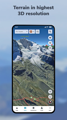


About this app
Developer Description
Ultra realistic 3D map with route planner, offline sat nav & GPS tracker
Best 3D map for challenging outdoor experiences, 3D route planner & tracking
Are you ready for unique outdoor experiences and exciting new places? The RealityMaps app is your perfect companion for challenging adventures – with the most accurate 3D map of all apps.
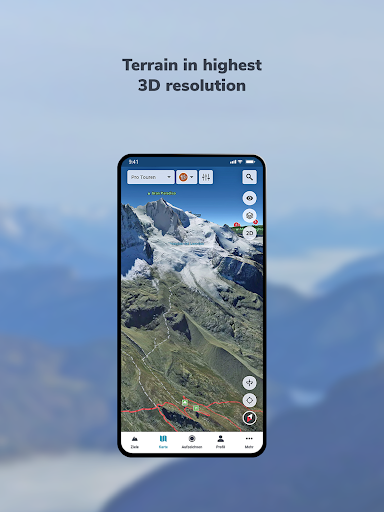
We create our realistic 3D map from aerial and satellite images using innovative technology. This allows you to accurately assess the terrain and plan your tour with confidence.
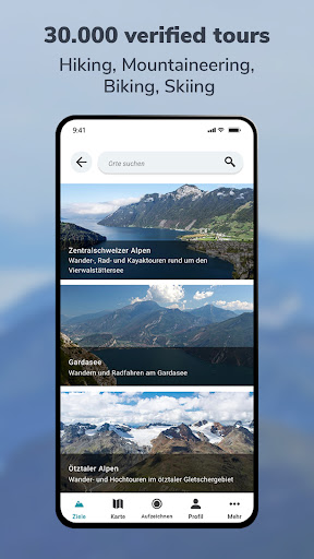
Be inspired by over 30,000 verified tours for hiking, biking, mountaineering, or skiing – in Europe's most beautiful mountain regions. Or plan your own routes directly in the 3D map, even off the beaten track.
Additional map information on hiking and biking trails, as well as slope gradient and orientation, will help you with your planning. The app also offers GPS tracking, GPX import, offline maps, and access to more than 5,000 webcams showing current conditions.
VERIFIED TOUR VARIETY
The app offers exclusively hiking, mountain, ski, and bike tours from Bergverlag Rother and other partners, thoroughly researched by experts. With the GPS, you can easily follow the marked routes of the tours.
DETAILED MAP MATERIAL
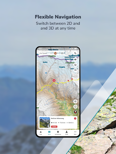
A topographical map in 2D and 3D complements the 3D map. Additional map layers provide information on hiking and cycling trails, as well as slope gradients and slope orientation.
GREATER SAFETY
The app offers the highest level of safety. The 3D map allows you to see the steepness and condition of the terrain and identify potential hazards. The resolution of the 3D map is so good that you can orient yourself even in bad weather, in fog, or at night.
GPS TRACKING
GPS tracking transforms your smartphone into a fully-fledged navigation device. While on tour, your current location is always displayed live on the 3D map.
PLANNING TOURS
With the routing function, you can plan your own routes directly on the 3D map or the topographic map. You can plan routes along existing paths or a route through pathless terrain to discover unique places.
RECORD AND SHARE YOUR TOURS
With GPS tracking, you can record tours and view the route you've taken live on the 3D map. Duration, distance, elevation, and speed are continuously recorded. Create your personal user account to save the recorded tracks, transfer your tracks to other smartphones or tablets, and share them with friends.
IMPORTING TOURS AS GPX
For unlimited tour variety, you can import tours in GPX format or from Komoot into the 3D map. This puts the entire world of hiking, biking, and mountain tours from the internet at your fingertips.
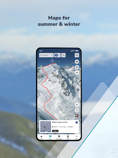
MAPS FOR SUMMER & WINTER
Global coverage with satellite images. High-resolution 3D map for the entire Alps and Pyrenees (summer & winter), as well as for other selected mountain regions in Europe (summer only).
OFFLINE MAPS
Important for your safety: download selected regions of the 3D map on your smartphone for use without an internet connection.
Try PRO features free for 7 days with no obligation.
Register and try all PRO features free for one week.
- Detailed tour descriptions
- Unlimited tour recording, saving, sharing, and transferring to other devices
- All map layers (2D and 3D, aerial photography and topographic maps, hiking and cycling trails, slope gradient and slope orientation)
- Save the 3D map to your smartphone for offline use
- Plan tours in 3D
- Automatically synchronize self-recorded, planned, and imported tours between the app and the web tour planner
What's New
In-app purchases
$4.49 - $54.99 per item
Version Information
- Version
- -
- Downloads
- 100K+
- Updated on
- Dec 23, 2025
- Released
- Jun 25, 2013
- Requires
- Android Varies with device
Statistics
Google Play Rating History
Rating Distribution
Downloads Over Time
RealityMaps: ski, hike, bike has been downloaded times. Over the past 30 days, it averaged downloads per day.
Shaded area shows 30-day prediction based on historical trends
Historical data collection started recently. More data points will be available over time.
RealityMaps: ski, hike, bike - Google Play Rankings
Top Rankings
| Rank | Country | Category | List | Change |
|---|---|---|---|---|
| — |
Ranking History in
No ranking data available yet. Rankings are updated daily.
#31 in Top Grossing Maps And Navigation in Germany
 Tracker - for dogs and outdoor
RealityMaps: ski, hike, bike
Tracker - for dogs and outdoor
RealityMaps: ski, hike, bike
 Gaia GPS: Offline Trail Maps
#57 in Top Grossing Maps And Navigation in Italy


#99 in Top Grossing Maps And Navigation in Poland


RealityMaps: ski, hike, bike users say on Google Play
 Zein Salami
Great app to explore potential adventures in Alps. It really gives great 3D views and makes you feel as if you are flying over the land
 Andrej Zupančič
The 3D views of the terrain can be very useful and help considerably in planning your outings. So, this aspect could possibly earn the app even a 5-star rating. But, it's terribly annoying to see established, local Slovenian place names written in German. That probably makes the use of this app harder, as nowadays not many Slovenes could help you if you are looking for "Mitterdorf", for instance. But, the developers responded really quickly to my gripes and acknowledged the poblem, so, kudos!
 A Google user
Would like to see maps for the US. Also, would like to see every detail translated to English. It is a very nice start though.
 u jawalikar
Only France not india
 Rafael Saint
hi after installation and update there appears an error: boost filesystem create directory permision denied... I m using lg g4 running os android 6 I gave the app all permisions possible but still the same error.. after latest update error is gone
ApkTrusted Ratings & Reviews
More from 3D RealityMaps
See more apps

Similar Apps

bergfex: Hiking & Tracking
Free

swisstopo
Free
National Park Service
Free

Bike Route Planner
Paid
Trails Offroad: Offline Maps
Free

HiiKER: The Offline Hiking app
Free

BaseMap: Hunting Maps and GPS
Free
Gaia GPS: Offline Trail Maps
Free

Windmate
Paid

TrailLink: Bike, Run, Walk
Free

Outdooractive. Hike and Ride
Free

Footpath Route Planner
Free

calimoto — Motorcycle GPS
Free

DeRadar
Paid
MysteryHike: Travel & Explore
Free

Trippy Tour Guide
Free
Scan this QR code to download

Forwarding you to the page at Google Play market in seconds...
Open Google Play market now