
Visorando - Walking routes v3.17.1
Visorando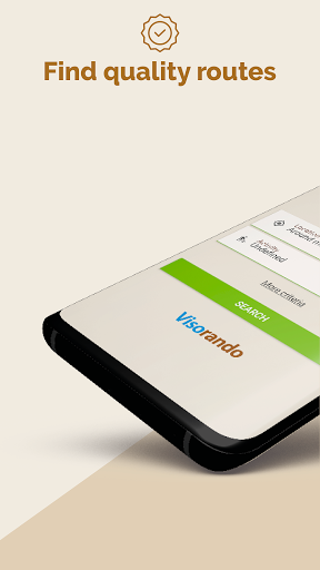
About this app
Visorando - Walking routes solves the problem of finding high-quality walking routes across the UK by providing OS maps, benefiting outdoor enthusiasts and hikers who need accurate and reliable navigation. Compared to alternatives in the Travel And Local category, Visorando stands out with its excellent user rating and large download base, indicating a well-regarded and popular app. However, its limited geographical focus might fall short for users seeking global coverage. The app's strong reputation and lack of ads are notable advantages.
Pros
- With over 5 million downloads and a 4.7-star rating, Visorando has demonstrated its value to a large and satisfied user base, indicating a high level of social proof and trustworthiness.
- The app's lack of ads provides an uninterrupted user experience, allowing hikers to focus on their routes without distractions, which is a significant advantage over ad-supported alternatives.
- Visorando's developer, Visorando, has a professional website and provides a contact email, suggesting a commitment to user support and transparency, which is essential for an app that handles sensitive user data.
- The app's offline capability, implied by its functionality, is a significant advantage for users who often find themselves in areas with limited internet connectivity, making it a reliable choice for outdoor activities.
- Visorando's regular updates, as indicated by its version history, suggest an active development process that ensures the app stays relevant and functional, addressing user needs and concerns.
Cons
- The app's limited geographical focus on the UK might be a significant drawback for users who require walking routes in other countries, making it less versatile than some alternatives.
- The in-app purchase model, with prices ranging from $5.99 to $23.99, might be perceived as expensive by some users, potentially limiting accessibility for budget-conscious hikers.
- The lack of information about the specific data collected by the app, despite its zero-permission policy, might raise concerns among privacy-conscious users who prefer transparency in data handling.
- Some users might find the app's user interface or features to be less intuitive or comprehensive compared to other hiking apps, which could impact the overall user experience.
Best for: The ideal user for Visorando - Walking routes is an outdoor enthusiast, likely between the ages of 25 and 55, with a moderate to high level of technical skill, who regularly goes hiking or walking in the UK and values accurate and reliable navigation, seeking an app that can provide high-quality OS maps and a user-friendly interface to enhance their outdoor experiences.
Developer Description
Discover high-quality walking routes across the UK with OS maps
Millions of people use the mobile app to explore paths worldwide.
📂 A WIDE CHOICE OF ROUTES
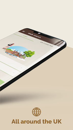
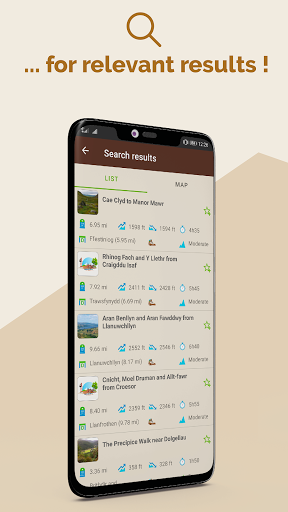
Find routes all over the United-Kingdom, matching your own needs for free - whether it’s a hike in the mountains or a stroll in the countryside, along the coast, into the woods or even in the city-even abroad. From a family walk to a strenuous hike, for a ramble on your doorstep or your next holidays, find what suits you best ! Walk or cycle, choose your own activity depending your location, the level and the duration you wish.
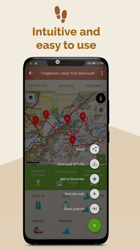
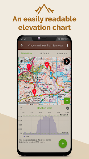
Each route sheet includes an OpenStreetmap map, a GPX, a step-by-step description, length, elevation gain, maximal and minimum altitudes, elevation chart, points of interests, level, weather forecast, and depending on user’s contribution photos and reviews.
Find more than 26 000 curated routes available world-wide (more than 3 500 of which in English).
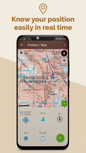
🗺️ LOCATE YOURSELF ON THE MAP AND LET BE GUIDED, EVEN OFFLINE
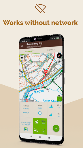
When you found the right itinerary, download it offline before leaving, then press the button start to follow the route. The GPS app will guide you even off the grid. You will be able to see your live location and your real time progress on the map. If you go off-track, an alert will warn you.
While moving, the actual route is recorded so afterwards you can share it, analyse it, compare it with the one plotted or simply walk it again later.
📱 PLOT AND RECORD YOUR OWN CUSTOMISED ROUTE
Doesn’t any of the route suits you? No worries, you can :
- Plot your own route, thanks to our route planner available for free from your laptop via our website (and from your mobile phone if you subscribed to Visorando Premium). When your route is saved on your computer, an automatic synchronisation allows you to find it over all your devices (mobile phone, tablet) where you are connected with your Visorando account.
- Record a live route and follow your progress on the map (distance, duration, elevation gain…). If you lose
yourself, you will be able to find your way back by following the route you just recorded.
- Import a GPX file
⭐ VISORANDO PREMIUM : Premium subscription to explore even further
We offer Premium Visorando during a 3 days trial period when you first register on the app. Then, you can subscribe for £5/month or £21/year.
Visorando Premium give you access to several add-on features such as :
- Access a collection of licensed topographic maps from your mobile phone : OS Explorer, IGN France, Swisstopo Switzerland, Belgium and Spain.
- Share you live position to reassure your loved-ones
- Hour per hour, detailed weather forecast of your route
- Organise and create files to keep your routes in order
- And many more…
Manage your subscription and choose if you wish to have it automatically renewed or not.
⭐ OS EXPLORER MAPS : the reference for any outdoor lover
Users who subscribe to Visorando Premium have access to the OS Explorer maps 1:25 000 scale on mobile phone : it allows to precisely visualise, elevation, contours, details related to the terrain. It also offers many information related to tourist and leisure activities, and gather national trails and other public right of ways.
🚶 A QUALITATIVE CONTENT
Visorando is a participative platform and community where anyone is welcome to share his/her own route. To assure the quality of the route published, each submitted one goes through a process composed by several steps, where it is checked and edited by a team of volunteers and agreed with the author, before being published.
📖 MANUAL
A manual to help you use the mobile app is available here : https://www.visorando.com/en-gb/article-user-guide-how-to-use-the-app-visorando.html
Privacy
Given Visorando's zero-permission policy, it appears to pose minimal risk to user privacy, as it does not request access to sensitive data such as location, contacts, or device information. However, users should still be cautious when making in-app purchases and ensure they understand what they are buying. To protect their privacy, users should review the app's terms of service and privacy policy, if available, to understand any potential data collection practices.
Tips
To get the most out of Visorando, users should first explore the app's offline capabilities to understand how to download and use maps without internet connectivity. Additionally, users can optimize their experience by regularly updating the app to ensure they have access to the latest features and maps. For improved performance, closing unnecessary apps and clearing storage can help prevent crashes and ensure smooth navigation.
What's New
💡 Route creation tool redesign:
• Automatic route drawing mode
• Smoother editing: add points by tapping on the map or the route
• Undo and redo system for actions
⛶ Fixed a bug related to QR Codes
⚠️ If you update from a version earlier than 3.16.0, your downloaded maps will no longer be available. You will need to download them again.
In-app purchases
$5.99 - $23.99 per item
Version Information
- Version
- 3.17.1
- Downloads
- 5M+
- Updated on
- Jan 8, 2026
- Released
- Jul 3, 2015
- Requires
- Android 6.0
Statistics
Google Play Rating History
Rating Distribution
Downloads Over Time
Visorando - Walking routes has been downloaded times. Over the past 30 days, it averaged downloads per day.
Shaded area shows 30-day prediction based on historical trends
Historical data collection started recently. More data points will be available over time.
Visorando - Walking routes - Google Play Rankings
Top Rankings
| Rank | Country | Category | List | Change |
|---|---|---|---|---|
| — |
Ranking History in
No ranking data available yet. Rankings are updated daily.
#1 in Top Grossing Travel And Local in France


#12 in Top Grossing Travel And Local in Pakistan


#12 in Top Grossing Travel And Local in Vietnam
#13 in Top Grossing Travel And Local in Egypt

Visorando - Walking routes users say on Google Play
 Pippy Longstocking
really good helpful app, some of the instructions need to be clearer though, make sure to follow your route on the map
 Wojciech
Good choice of hikes, app is having some issues though. For example downloading maps for offline use doesn't work. They're just stuck at 0% (9 tiles) while still connected to wifi.
 Jacqueline McCleary
Why on earth doesn't this app have a start/stop button while recording activity? I literally had to uninstall it to get it to stop buzzing at me that I was off-route after getting home! Such a dumb feature to have left out. Also, sometimes the app will randomly zoom alllll the way out to world-level view, and I have to stop and pinch-zoom it until I can see where I am again. Giving it two stars because it does work, but there's no way I'm paying for premium until these bugs get fixed.
 adrian
Paid for the premium but I was not given access to the promised maps (IGN etc.). App still sents to subscription page, and if i choose 1 month, app tells that I have already paid for the premium subscription. Logged in using laptop and account shows I have premium. But is useless as I cannot access the layers I have paid for. Wrote mail to support. Still waiting for the reply.
ApkTrusted Ratings & Reviews
Similar Apps

Outdooractive. Hike and Ride
Free

bergfex: Hiking & Tracking
Free

Polarsteps
Free

Footpath Route Planner
Free

Gaia GPS: Offline Trail Maps
Free
Map My Walk: Walking Tracker
Free

swisstopo
Free

Decathlon Coach - fitness, run
Free

Cyclers: Bike Navigation & Map
Free

Mapy.com: Offline hiking maps
Free

Map My Ride With GPS Tracker
Free

Trippy Tour Guide
Free

HiiKER: The Offline Hiking app
Free

Bikemap: Cycling Tracker & GPS
Free

Bonjour RATP
Free

FarOut
Free
Scan this QR code to download

Forwarding you to the page at Google Play market in seconds...
Open Google Play market now