
WeTrek (ex IGNrando') vVARY
Ubicarta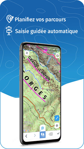

About this app
Developer Description
Hiking app for France & Europe, offline topo maps, route planning & guiding
MAPS & LAYERS IN FREE ACCESS (with internet connection)
• Plan IGN: most updated map, suitable for all activities
• Aerial photos (IGN)
• OpenStreetMap Outdoors: world map with hiking routes & contour lines
• OpenCycleMap: world map with cycling routes & contour lines
• Spain IGN map
• Swisstopo map
• Emergency calls (112) mobile network coverage map for France
• OpenSnowMap
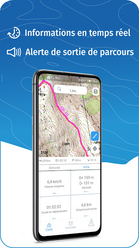
GPS GUIDING ALONG ROUTES
• See your progression on the altitude graph
• Get alerted if you exit the route
GPS TRACKING AND DATA CREATION
• Record your own routes with GPS tracking
• Quickly create routes on-device with the automatic routing tool that follows roads and paths (online only, with subscription)
• Create Points of interest
• Backup your route on the WeTrek platform
OFFLINE USE
• The GPS keeps working even without internet: see your position on the map, use GPS guiding and record routes
• Downloaded routes: descriptions, photos and guiding remain accessible
• Downloaded maps (with subscription)
Useful tip: Enabling Airplane Mode or disabling Mobile Data improves battery life, without affecting the Location Services (GPS)
WETREK PLUS SUBSCRIPTION
• Create routes with pedestrian and vehicle routing
• View & download the following maps & layers:
∙ All free version maps
∙ IGN maps (various scales)
∙ IGN 1:25k topo maps (Top 25): the famous French topographical maps available at all zoom levels
∙ 1950 IGN maps
∙ Military maps (1820-1866)
∙ ICAO aeronautical charts
∙ France mobile network operators coverage maps
∙ Slopes > 30° (useful for winter activites)
∙ Cadastral parcels layer
∙ DFCI grid (forest fire protection grid)
• Drones flight restriction areas
∙ Roads & paths layer (only available with Aerial photos)
Play Store subscription
• Linked to Google account
• Automatic renewal unless cancelled at least 24 hours before the end of the current period
• Auto-renewal may be turned off after purchase
Ubicarta store subscription
• Linked to your Ubicarta account
• Purchase & manage your subscription on wetrek.ubicarta.com
• Can be used on 3 devices at the same time (Android & iOS)
Use an SD card to store your data
Free space on your device.
——————————————————————
The app uses your network connection to stream maps or to download content or maps. Carrier charges may apply.
The app uses your device location to display it on the map, to record tracks and to share it to your friends.
Got ideas to improve WeTrek?
Write us on: support@wetrek.app
What's New
In-app purchases
$19.99 - $22.99 per item
Version Information
- Version
- -
- Downloads
- 500K+
- Updated on
- Dec 10, 2025
- Released
- Jul 17, 2019
- Requires
- Android Varies with device
Statistics
Google Play Rating History
Rating Distribution
Downloads Over Time
WeTrek (ex IGNrando') has been downloaded times. Over the past 30 days, it averaged downloads per day.
Shaded area shows 30-day prediction based on historical trends
Historical data collection started recently. More data points will be available over time.
WeTrek (ex IGNrando') - Google Play Rankings
Top Rankings
| Rank | Country | Category | List | Change |
|---|---|---|---|---|
| — |
Ranking History in
No ranking data available yet. Rankings are updated daily.
#5 in Top Grossing Travel And Local in France


#49 in Top Grossing Travel And Local in Pakistan

#50 in Top Grossing Travel And Local in Vietnam
#51 in Top Grossing Travel And Local in Egypt
WeTrek (ex IGNrando') users say on Google Play
 Simon H
Works well. Easier to use than our online British Ordnance Survey maps. I like the function that gives an easy to see distance between where you are and where you have put the cross hairs. If only piste maps were so reliable. I often used the IGN map when skiing to see "Where I really was...".
 Mike Taylor
I used this app daily while hiking in france It's not as good as Ordnance Survey, but it's a good app. The navigation / user experience is a little clunky. There's a good selection of user contributed trails (I think you can only create these by recording, I couldn't figure it out), the filtering on the selection is a little wild. But I wouldn't go hiking without it! Vive le IGN !
 Frank Schweppe
I used ViewRanger, which was an excellent app to get access to downloaded offline IGN maps (the whole social network buddy stuff does not interest me at all but that's OK, you don't need to use it). Unfortunately ViewRanger is no more, sold out to another app that is worse. IGN Rando is the obvious one to use instead. Have downloaded it but use will be limited until the possibility to download maps on an SD card becomes available. For anyone designing ths kind of software, do realize that just where you need topo maps, in the outdoors, connection to a 4G data network is often bad or non existent. So you really need preloaded maps of a fairly large area, and that is just too much data for the phone's internal memory (unless you have a very expensive phone with huge internal storage, and even then, if you also need to store pictures and videos etc. there, it still fills up). Keeping maps on an SD card is way better. Once it has that option I'll give it more stars...
 Mathieu Louis
Sluggish, crashes very often, very bad UI. After downloading the maps and using offline mode it takes forever to draw the map when zooming in. The only positive thing is the actual content of the official IGN maps, I wish this content was be available in a properly developed and designed app. I'm not confident relying on this app for navigation in remote mountains.
 a mig
a mig
Downloading maps for offline stalls most of the time and is painfully slow. Offline maps if the download managed to succeed does not seem to work much. Back to paper maps then.
ApkTrusted Ratings & Reviews
More from Ubicarta
See more apps

Similar Apps


Scan this QR code to download

Forwarding you to the page at Google Play market in seconds...
Open Google Play market now