
Rother: Hiking & Maps v2.0
Bergverlag Rother GmbH


About this app
Developer Description
The most beautiful tours - reliable hikes and premium maps
Here comes your reliable companion for the next hike!
With us there is no mess of useless tours, but only tour suggestions from professional authors - tested and regularly updated. With our maps from qualified cartographers, orientation is easy. For beautiful and safe outdoor experiences.
The Rother App is developed and published by Rother Bergverlag, known for reliable hiking guides.
FREE OFFLINE MAPS
You can download our hiking and biking maps for free and use them offline. You can also plan your own routes and record your adventures.
GET ALL TOURS AND MAPS
You have the choice: Unlock individual guides or get them all in the low-priced Gold subscription. This gives you access to all tours from Rother, all premium maps from freytag & berndt, Swisstopo and the satellite map. You can save tours and locations in your own lists, so you can keep track of everything.
EASY TOUR SELECTION
Do you want a leisurely tour today or are you looking for a challenge? Are you looking for a child-friendly hike? No problem: easily filter tours according to your preferences, such as length and difficulty.
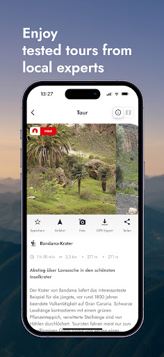
HIKING MAPS
Topographic maps in many zoom levels and satellite map. With our premium maps you get the finest cartography from freytag & berndt and others like Swisstopo, BKG, SHOCart, CNIG or Kartverket.
GPS NAVIGATION
While hiking you can always see your location and the track of the tour.
OFFLINE USE
Simply download the map for the desired area and go hiking without an internet connection.
ROUTE DESCRIPTIONS
Reliable tour descriptions and all information about requirements, refreshments, etc.
In a slideshow with photos of the tour you can see what to expect.
PLAN YOUR OWN ROUTE
Route planning with Rother is very easy and understandable: enter your start and destination and we will show you the way - on foot or by bike.
ROTHER GUIDES
You can also get our popular Rother hiking guides. Each guide contains around 50 tested tours by proven area experts.
There are more than 200 guides available for the most beautiful hiking regions worldwide - also for the Way of St. James and long-distance hiking trails as well as for winter (ski tours, snowshoe tours).
If you already have a book from us, you can import the GPS data into the app for free, but not unlock the corresponding guide for free.
ABOUT ROTHER BERGVERLAG
Rother Bergverlag is Europe's most important publisher of hiking guides. The authors are proven area experts who stand for a considered tour selection and the highest quality. All tours are professionally checked in the editorial office.
What's New
In-app purchases
$6.99 - $31.99 per item
Version Information
- Version
- 2.0
- Downloads
- 100K+
- Updated on
- Oct 30, 2025
- Released
- Jul 11, 2013
- Requires
- Android 7.0
Statistics
Google Play Rating History
Rating Distribution
Downloads Over Time
Rother: Hiking & Maps has been downloaded times. Over the past 30 days, it averaged downloads per day.
Shaded area shows 30-day prediction based on historical trends
Historical data collection started recently. More data points will be available over time.
Rother: Hiking & Maps - Google Play Rankings
Top Rankings
| Rank | Country | Category | List | Change |
|---|---|---|---|---|
| — |
Ranking History in
No ranking data available yet. Rankings are updated daily.
#11 in Top Grossing Travel And Local in Germany

#29 in Top Grossing Travel And Local in Italy


#30 in Top Grossing Travel And Local in Netherlands


#44 in Top Grossing Travel And Local in Pakistan

Rother: Hiking & Maps users say on Google Play
 Daria Maria Daves
Always happy with the hikes and the app!
 Alexei Sadovnikov
Ich habe einige Rother Bücher gekauft und die gpx Dateien importiert. Nach dem Update sind sie alle weg, Import ohne ein Account funktioniert nicht.
 Nicolas Bertin
So far many tours are missing in the gold version. For example in France, the tours in Normandy, the Loire Valley, Burgundy or Ile de France are all missing. You will find Brittany or Northern France, but not those four. So I'm guessing it's gonna be the same for other countries, and a big percentage of the tours you see in books are still missing. I guess they will be adding them progressively, but they should tell you beforehand... Also the map zooming is very slow and buggy...
 Emma Díaz González
Dissapointed with the new version. Great that it is now in English, but it has lost some functionality: Tour numbers are gone, but references inside description are still with number. No way to know whic tour it is; Elevation profile does not allow to follow it on the trail (other apps let you select a specific point on the elevation profile and it shows you where that is on the trail); Arrows to indicate direction of tour have disappeared, annoying; It can never find any tours on the region
 A Google user
Rubbish, even if I bought the book, I can't use the app for a certain route. Will never buy anything from Rother in the future.
ApkTrusted Ratings & Reviews
Similar Apps

bergfex: Hiking & Tracking
Free

Outdooractive. Hike and Ride
Free

Mapy.com: Offline hiking maps
Free

swisstopo
Free

Gaia GPS: Offline Trail Maps
Free

HiiKER: The Offline Hiking app
Free

Guru Maps Pro & GPS Tracker
Paid

OsmAnd — Maps & GPS Offline
Free

Polarsteps
Free

calimoto — Motorcycle GPS
Free

Magic Earth Navigation & Maps
Free

HERE WeGo: Maps & Navigation
Free

Footpath Route Planner
Free
Trailforks
Free

AlpineQuest Explorer Lite
Free

Mapway: Maps & Transit Planner
Free
Scan this QR code to download

Forwarding you to the page at Google Play market in seconds...
Open Google Play market now