
CalTopo v1.24.2
CalTopo LLC


About this app
Developer Description
Backcountry mapping evolved
Cloud Sync
New on CalTopo: the CalTopo app is now satellite ready, allowing you to use many features of the app offline with satellite data!
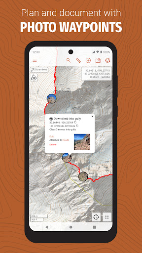
The CalTopo app integrates with your existing caltopo.com account, and edits sync between the two in seconds. Plan your trip using CalTopo's best-in-class mapping tools and then seamlessly transition to your phone. Once in the field, sync your GPS track back to caltopo.com in real time, or drop markers and instantly share them with friends.
Amazing Maps
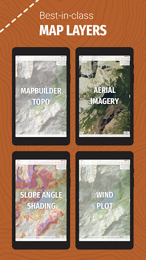
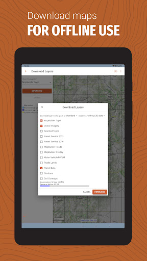
Access CalTopo layers not available elsewhere, including the MapBuilder series, land management, sun exposure, fire activity and custom terrain shading. Pre-packaged map files (subscription required) make for speedy offline downloads and simplified data management. An elevation data layer supports measuring profiles and point elevations, even when offline.
Real-Time Data
NOAA weather forecast visualizations and MODIS satellite imagery aid in-field decision making. Coming soon: SNOTEL, weather stations, streamflows and forecast grid data points.
What's New
Version Information
- Version
- 1.24.2
- Downloads
- 100K+
- Updated on
- Jan 9, 2026
- Released
- Sep 21, 2020
- Requires
- Android 5.1
Statistics
Google Play Rating History
Rating Distribution
Downloads Over Time
CalTopo has been downloaded times. Over the past 30 days, it averaged downloads per day.
Shaded area shows 30-day prediction based on historical trends
Historical data collection started recently. More data points will be available over time.
CalTopo users say on Google Play
 jdc
jdc
I've been doing hardcore wilderness/ off trail navigation for 30 years and finally a SERUOUS nav system. not just an app, A system. web app allows me to plan and set routes. walk-by-gps app works fine, but I use compass+map and the maps made with CalTopo are second to none. LOVE this system, can't speak highly enough of it for serious /hardcore nav geeks. I hate subscriptions for software, but this is one (the ONLY one) I buy - it's THAT good.
 Darren Siongco
Not that easy to use. Some URL icons don't work. Super limited use with the free version.
 Adam P
very promising, but clunky. This app has incredible functionality in the free version, especially when compared to other apps, but it takes a while to figure out how to use it. I would be interested in trying the premium version but there's no way for you to sign up in the app! I guess I'll just keep my money...
 Stephen Crye
and otherwise decent mapping application is ruined by clunky and inconsistent login process! For example, to sign up to their help tracking system, you create an account on caltopo itself with a password that is dedicated to that login. But when you try to upgrade or add a pro subscription, it expects you to still use an existing social media accounts such as Google or Facebook. this is total BS! why can't I just upgrades directly from the app? instead, it sends me to a browser! Fire the IT team
 Arthur Arthur
The mobile app is a total Fail if you are trying to navigate in an offline environment like... deep in the wilderness or even state or national parks where internet is not available. It simply doesn't work and I have had much conversation with support on this to be sure it wasn't me. I have the Desktop subscription and mainly bought this to build maps for print and for that, this app is the absolute best. So, the rating is for the mobile app only.
ApkTrusted Ratings & Reviews
Similar Apps

HiiKER: The Offline Hiking app
Free

FarOut
Free

Gaia GPS: Offline Trail Maps
Free

Footpath Route Planner
Free

Avenza Maps: Offline Mapping
Free
Trailforks
Free

Mergin Maps: QGIS in pocket
Free
PeakFinder
Paid

TrailLink: Bike, Run, Walk
Free
Trails Offroad: Offline Maps
Free

Holland America Line Navigator
Free

KAYA: THE CLIMBER’S APP
Free

swisstopo
Free

Gaggle Paragliding, Ultralight
Free
National Park Service
Free

GPS Essentials
Free
Scan this QR code to download

Forwarding you to the page at Google Play market in seconds...
Open Google Play market now