GPS Field Area Measure : GLand v3.25.1
Maps Tools Utilities Team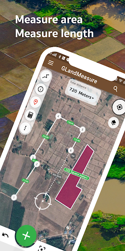


About this app
Developer Description
area measure, land measure, length measure, kml, gps, geojson, measurement app
Tired of inaccurate land estimates? GLandMeasure is your ultimate precision tool for all land surveying and GIS needs. Easily and quickly calculate areas, measure distances, determine perimeters, define property lines, and manage complex geospatial data with confidence.
Discover the Power of GLandMeasure:
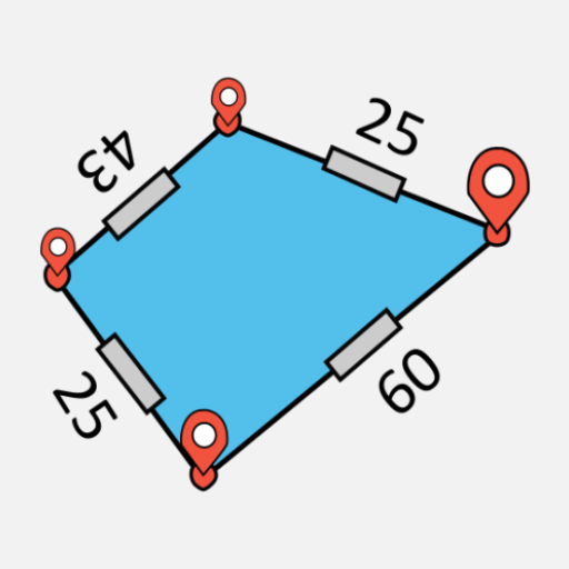
🌟 Accurate Area Calculator: Instantly find the area of any land, field, farm, lot, or property. Perfect for calculating acreage!
🛰️ GPS Land Measurement: Utilize high-precision GPS for reliable field area data, mapping, and boundary surveys.
🚶 Measure Area by Walking: Simply walk the perimeter to map out exact boundaries – ideal for irregular shapes, paths, and paddock measurements!
📏 Easy Distance Tool: Quickly and conveniently calculate distances between points on your map or on-site.
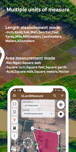
🌐 Flexible Unit Converter: Effortlessly switch between various units: Acres, Square Feet (sq ft), Square Meters (sq m), Hectares (ha), Square Kilometers (sq km), Miles (mi), Kilometers (km), Feet (ft), Yards (yd), and more.
GLandMeasure is the Go-To App For:
Farmers & Agricultural Professionals: Manage farmland, measure field acreage, plan crops, and optimize resources.
Real Estate Agents, Appraisers & Developers: Confidently measure property sizes, verify lot dimensions, and enhance listings.
Land Surveyors, Engineers & GIS Professionals: Obtain reliable data for surveys, construction, environmental assessments, and GIS analysis.
Homeowners & Landowners: Accurately determine your property lines, plan landscaping or fencing projects.
Outdoor Enthusiasts & Planners: Measure trails, map out recreational areas, or plan construction layouts.
Advanced GIS & Surveying Capabilities:
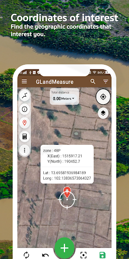
🌐 Multi-Coordinate System Support: Work seamlessly with various global and local coordinate systems including GEO (Latitude/Longitude), DMS (Degrees, Minutes, Seconds), UTM (Universal Transverse Mercator), MGRS (Military Grid Reference System), Geohash, and Plus Codes.
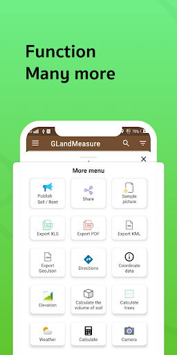
📤 Versatile Export & Sharing Options:
Share coordinates instantly.
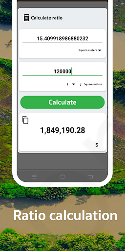
Export your project data to KML, GeoJSON, Excel (CSV), and professional PDF reports.
⛰️ Elevation & Terrain Analysis:
Access altitude data for any point or area.
Visualize terrain with contour lines for better understanding of topography.
Calculate soil volume (cut and fill estimations) for earthworks and landscaping projects.
🌳 Area Analytics: Perform quick tree count estimations within measured areas for forestry or planning.
🌦️ Local Weather Forecast: Get on-the-spot weather predictions integrated for your surveyed location.
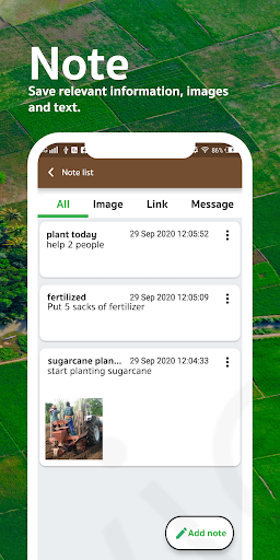
📍 Save & Manage Points of Interest: Easily save, label, and manage important locations, waypoints, or survey markers.
📸 GIS Camera: Capture georeferenced photos to document fieldwork, tag specific points of interest, and integrate visual data with your maps. (This assumes capturing photos with location data, not area measurement via camera view).
⏱️ Built-in GPS Speedometer: Ensures accurate tracking and data collection during walk measurements.
🗺️ Clear Satellite Map View: Provides excellent visual context for your measurements and planning.
Stop guessing. Start measuring with confidence! Download GLandMeasure today for the most comprehensive, user-friendly, and accurate solution for all your land, field, distance measurement, and GIS data needs!
What's New
Land measurement and length calculation made easier by dragging coordinates.
Share and forward information to social media such as Facebook and others. For example, posting real estate for sale.
Added functions: import KML, calculate land volume, measure land elevation, calculate trees, added image layer.
Add points of interest.
Separate project creation
Camera added to the app.
Added GeoJson, Geohash.
In-app purchases
$2.99 - $99.00 per item
Version Information
- Version
- 3.25.1
- Downloads
- 5M+
- Updated on
- Sep 15, 2025
- Released
- Jul 14, 2017
- Requires
- Android 5.0
Statistics
Google Play Rating History
Rating Distribution
Downloads Over Time
GPS Field Area Measure : GLand has been downloaded times. Over the past 30 days, it averaged downloads per day.
Shaded area shows 30-day prediction based on historical trends
Historical data collection started recently. More data points will be available over time.
GPS Field Area Measure : GLand - Google Play Rankings
Top Rankings
| Rank | Country | Category | List | Change |
|---|---|---|---|---|
| — |
Ranking History in
No ranking data available yet. Rankings are updated daily.
#16 in Top Grossing Maps And Navigation in Thailand


#19 in Top Free Maps And Navigation in Thailand


#23 in Top Free Maps And Navigation in Vietnam
 Bản đồ thông tin quy hoạch VN
GPS Field Area Measure : GLand
Bản đồ thông tin quy hoạch VN
GPS Field Area Measure : GLand
 Compass app - Accurate Compass
#24 in Top Free Maps And Navigation in Indonesia
 GPS Camera: Photo Location Tag
GPS Field Area Measure : GLand
GPS Camera: Photo Location Tag
GPS Field Area Measure : GLand
 MarineTraffic - Ship Tracking
GPS Field Area Measure : GLand users say on Google Play
 Lj Sunday
Great app with a user-friendly interface. I highly recommend it to be used by professionals.
 Abdul Qayyum
Good App 90% Correct Result
 Eng alwaaer
nice
 Bruce Eggleston
ads mess up the point sets and can't stop when you want to end points
 Waseem Waseem
ok
ApkTrusted Ratings & Reviews
More from Maps Tools Utilities Team
See more apps
Similar Apps

Avenza Maps: Offline Mapping
Free
Save Location GPS
Free

Compass & Altimeter
Free

My Location - Track GPS & Maps
Free

AlpineQuest Explorer Lite
Free
Easy Area : Land Area Measure
Free

MAPS.ME: Offline maps GPS Nav
Free
GPS Map Camera
Free

My Track
Free

Nautide: Tides, Wind, Waves +
Free
Karta GPS Offline Maps Nav
Free

GPS Essentials
Free

Gaia GPS: Offline Trail Maps
Free

ShipAtlas - Ship Tracker
Free
Geo Tracker - GPS tracker
Free

OsmAnd — Maps & GPS Offline
Free
Scan this QR code to download

Forwarding you to the page at Google Play market in seconds...
Open Google Play market now