
OruxMaps GP vVARY
jose vazquez


About this app
Developer Description
A tool for outdoor activities.
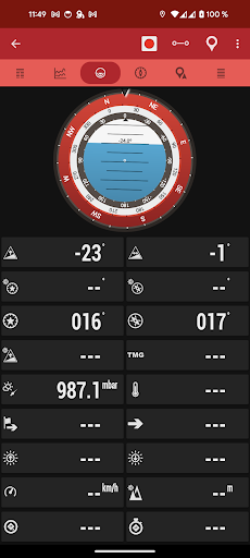
It is an Online and offline map viewer. With this app you can use different map formats, like GeoPDF from USGS store, GeoTIFF maps, .ozf2, .img garmin (vectorial, no full support is provided), .mbtiles, and others.
Online maps: You can use the application as a WMS and WMTS online map viewer. Download online maps for offline use. NOT ALL ONLINE MAP SOURCES ARE NOW DOWNLOADABLE. SELECT ANOTHER SOURCE IF YOU CAN NOT FIND THE OPTION TO DOWNLOAD A MAP.
NEW! Added featured Mapbox and Google online maps (subscription required).
You can register into OruxMaps servers, but it is not mandatory, the app will work without this step. If you register an account, the app will ask for various personal information, including an email account, date of birth, sex, weight and height. This data will be stored on an OruxMaps server, and will not be shared with any other user, person or company; they are only at your disposal. If you delete your account, that data is deleted from the server.
If you want to use the 'multitracking' option, the app will ask you to choose in your contacts the emails of the users with whom you want to share your position. The email of these people will be stored on the server, so you can share your position with them. These emails will only be used for this purpose. If you delete your account, this information will also be removed from the server.
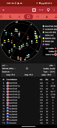
Support to multiple external devices, like external GPS, heart rate monitors, (including bluettoh smart 4.0 devices), bike cadence and speed, bike power, ANT+ (speed, cadence, heart rate, distance, cycle power, temperature).
It also can be used to control the tire pressure/temperaure.
And you can connect to AIS information systems for nautical sports, using Wifi, BT or USB.
You can see Routes and Tracks in different formats, like KML KMZ, TCX, FIT, CSV, SHP and GPX.
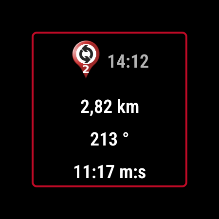
Share your position with your friends, display the position of your friends in your device.
Follow routes, with different alarms to alert you if you are near a waypoint, or you are far from the route.
Geofence/exclusion zone alarms with KML/KMZ overlays.
Create/save wayponits, attaching photo/audio/video extensions.
Custom Waypoint types, with your own icons. Attach forms to the Waypoints.
Basic support to Geocaching.
Correct the altitude of your tracks/routes using DEM files (offline) or online services.
Track editor tool. Modify track points (add, remove, move) if they are wrong.
Search/download tracks from different sources, like gpsies.com
Search or create tracks using online services from Graphopper or offline using Brouter app.
A simple app for Wear OS is included, allowing you to display basic data (a dashboard) and a simplified map (not synchronized with the map on the main device).
More information on the website.
What's New
In-app purchases
$0.99 - $8.99 per item
Version Information
- Version
- -
- Downloads
- 100K+
- Updated on
- Sep 29, 2024
- Released
- Nov 14, 2011
- Requires
- Android Varies with device
Statistics
Google Play Rating History
Rating Distribution
Downloads Over Time
OruxMaps GP has been downloaded times. Over the past 30 days, it averaged downloads per day.
Shaded area shows 30-day prediction based on historical trends
Historical data collection started recently. More data points will be available over time.
OruxMaps GP - Google Play Rankings
Top Rankings
| Rank | Country | Category | List | Change |
|---|---|---|---|---|
| — |
Ranking History in
No ranking data available yet. Rankings are updated daily.
#4 in Top Paid Travel And Local in United States


#1 in Top Paid Travel And Local in South Korea
#2 in Top Paid Travel And Local in France

#2 in Top Paid Travel And Local in Italy

OruxMaps GP users say on Google Play
 Maurício Clauzet
I love Orux Maps, so complete and powerful! For folks that are finding it complex, activate the "lite" user interface. Unfortunately having problems now on Android 13, I Cannot access the Android/Data folder, so I can't put new offline maps that I created outside of orux for example. I'm looking forward for an update that address that. I do prefer how it was in older versions, an orux folder on the root folder.
 Liberty Toad
The battery usage is very low. The UI is powerful, but you do need to mess around with it a bit to set it up and get used to it. Setting up the buttons you want to use makes this easier. DEM data works well, but getting the right area takes some trial and error. Track recording does not always record, sometimes it works, sometimes it doesn't. I tried to find a pattern for it but did not see one. It used to always work.
 User Name
The standard is 1km grid squares for utm. It's confusing when grid squares change to 500m and smaller as the zoom level changes. And the grid lines now have utm numbers but include extra unneeded numbers at start. Please fix.
 Waqas Mahmood
After update the utm zone are not accurate please fix this bug.
 Kalin Vasilev
The only app I ever paid for and ended up deleting. Crappiest UX ever. Menus are extremely hard to navigatte and remember. Nothing is simple or intuitive. Want to get a track started? Good luck finding a button that says so. Want to find your recorded tracks? That's an obscure tiny icon in one of the menu items, under one of the two hamburger menus! Had to use trial and error to find that every time. No I can't recommend an alternative, I just don't want to spend my time figting a poor UI.
ApkTrusted Ratings & Reviews
More from jose vazquez
See more apps
Similar Apps

Gaia GPS: Offline Trail Maps
Free

Mapy.com: Offline hiking maps
Free

HiiKER: The Offline Hiking app
Free

Avenza Maps: Offline Mapping
Free
Hikingbook: Hike, Bike & Run
Free

swisstopo
Free

FarOut
Free

Outdooractive. Hike and Ride
Free

Footpath Route Planner
Free

Mergin Maps: QGIS in pocket
Free

Locus Map Outdoor Navigation
Free

Orca: Boat GPS, Charts, Routes
Free

bergfex: Hiking & Tracking
Free

Mapway: Maps & Transit Planner
Free

Cyclers: Bike Navigation & Map
Free

Magic Earth Navigation & Maps
Free
Scan this QR code to download

Forwarding you to the page at Google Play market in seconds...
Open Google Play market now