Whympr - Ski, Hike, Climb v2.31.0
Whympr


About this app
Developer Description
The All-in-One App for Outings
Plan Smarter, Go Further
- 3D HD Maps: Explore detailed 3D terrain maps.
- Topographic Maps: Access 15 premium topo layers including IGN, SwissTopo, USGS, and high-quality Italian maps.
- HD Winter Satellite Map: Discover the world's most advanced winter satellite imagery (Feb 2025 update - Beta on the Mont-Blanc Massif).
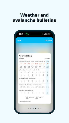
- Official Avalanche Bulletins (BERA): Check live avalanche reports.
- Mountain Weather: Detailed forecasts including freezing levels, sunshine, and past conditions.
- Slope Steepness: Visualize slope gradients and identify avalanche risk zones.
- GPS Tracking: Record and view your route before or during your outing.
- Community Activity: See where others have been in the last 10 days - explore their routes, photos, and insights.
Find the Perfect Route
- Browse detailed routes from Skitour, Camptocamp, and Gulliver.it.
- Access over 1,000 Pro Topos written by mountain experts like François Burnier (Vamos) and Gilles Brunot (Ekiproc).
- Filter by difficulty, activity type (ski touring, hiking, climbing, off-piste, snowshoeing, etc.) and duration.
- Stay safe by locating and avoiding patous (guardian dogs) directly on the map.
Stay on Track
- Peak Viewer (AR): Identify surrounding peaks in live augmented reality.
- Precise Geolocation: Find your position even without a network connection.
- Offline Mode: Download routes and maps for use anywhere.
- Points of Interest: Discover huts, passes, cliffs, and other key landmarks.
Share Your Adventures
- Join a community of over 600,000 outdoor enthusiasts.
- Check and share real-time snow and terrain conditions (ice, accumulation, avalanches, etc.).
- Keep your photos, stats, and memories in your personal digital logbook.
- Replay your outings with the Fly Over 3D feature.
- Inspire others and share directly to social media stories.
Go Premium
Try Whympr Premium free for 7 days! Unlock all maps (IGN, SwissTopo, etc.), 3D mode, offline navigation, and more. 👉 Annual subscription: €24.99
Web App
Plan your adventures from your desktop with the Whympr Web App. Included in the Outdoor Pack, which combines Whympr Premium, an Iphigénie map subscription, and access to the Web App. 👉 Annual subscription: €39.99
Our Commitment
Whympr donates 1% of its revenue to 1% for the Planet to help protect mountains and their environment.
Made in Chamonix
In the heart of the Alps, Whympr is an official partner of: ENSA (National Ski & Mountaineering School), FFCAM, SNAM, the Chamonix Guides Company, and ANENA (National Association for Snow and Avalanche Study). An app created by and for mountain lovers.
What's New
Whympr goes off the beaten track and offers you an exceptional new winter map of the Mont-Blanc massif designed to transform your mountain outings.
New High-Definition 3D Enhanced with LiDAR Technology
Visualize every ridge, every valley, and every slope with unparalleled precision.
Fly over
Fly over your outings and those of the community in 3D to relive the experience as if you were there.
In-app purchases
$1.99 - $39.99 per item
Version Information
- Version
- 2.31.0
- Downloads
- 100K+
- Updated on
- Dec 18, 2025
- Released
- Aug 16, 2018
- Requires
- Android 8.0
Statistics
Google Play Rating History
Rating Distribution
Downloads Over Time
Whympr - Ski, Hike, Climb has been downloaded times. Over the past 30 days, it averaged downloads per day.
Shaded area shows 30-day prediction based on historical trends
Historical data collection started recently. More data points will be available over time.
Whympr - Ski, Hike, Climb - Google Play Rankings
Top Rankings
| Rank | Country | Category | List | Change |
|---|---|---|---|---|
| — |
Ranking History in
No ranking data available yet. Rankings are updated daily.
#8 in Top Grossing Sports in France


#47 in Top Grossing Sports in Italy

#81 in Top Free Sports in France


Whympr - Ski, Hike, Climb users say on Google Play
 A Google user
This app is fantastic. Could not believe how easy it was to find trekking trails! I love to use Whympr because it so simple to trek and climb:)
 Toby Rickards
Best alternative to FATMAP I've found in the Alps. Only improvement would be to display the pro topo routes on to the map after I have purchased them
 Léo C
Léo C
Impossible de choisir sa langue, unités (métrique / imperial)
 Karsten Keese
The umptienth iteration of the same rip-off scheme based on the same template, and as always, bleeding consumers dry ad infinitum with recurring subscription fees. You have to create an account before you are even being allowed to take a look at the GUI and functionality, so expect to receive 'special offers' afterwards. There are functionally superior competitor products that can be bought instead of rented, which replaced this milkingware that is now being uninstalled.
A Google user
J'aimerai supprimer mes données et mon compte sauf que c'est impossible, aucun mail, aucun lien de suppression...pas très RGPD...
ApkTrusted Ratings & Reviews
Similar Apps
bergfex: Hiking & Tracking
Free

Outdooractive. Hike and Ride
Free

Trippy Tour Guide
Free
KAYA: THE CLIMBER’S APP
Free

FarOut
Free

swisstopo
Free

Cyclers: Bike Navigation & Map
Free

Footpath Route Planner
Free

Südtirol Fishing
Free
National Park Service
Free

SmartGuide: Digital Tour Guide
Free
eBike Flow
Free

The Mantrailing App
Free
Breathwrk: Breathing Exercises
Free

HiiKER: The Offline Hiking app
Free

Windmate
Paid
Scan this QR code to download

Forwarding you to the page at Google Play market in seconds...
Open Google Play market now